
The National Weather Service said a “significant” winter storm is becoming increasingly likely on Tuesday for south Alabama, and winter storm warnings have been issued for the region.
Snow is the most likely in south Alabama, and areas in north and north-central Alabama will likely miss out on this storm.
However, the weather service warned that arctic air in place will hang around for several days and keep temperatures well below average.
1/30
South Alabama is looking at the possibility of its most snowfall since 2017.
Two to 4 inches of snow will be possible across parts of south Alabama starting on Tuesday morning and lasting through the day and into Wednesday morning.
The National Weather Service in Mobile said the most likely snow amounts are 1 to 3 inches, but isolated areas of 4 to even 5 inches of snow can’t be ruled out.
The beaches even may see a wintry mix of snow, sleet and freezing rain, the weather service said, with the mainly snow expected.
The weather service cautioned that it won’t take a lot of snow to make travel very difficult because of very cold temperatures already in place. Travel could be affected Tuesday and Wednesday as well.
Here are the Alabama counties under winter storm warnings, which will go into effect on Tuesday:
SOUTHWEST ALABAMA
- Winter storm warning from 6 a.m. Tuesday until 6 a.m. Wednesday for Choctaw, Washington, Clarke, Wilcox, Monroe, Conecuh, Butler, Crenshaw, Escambia, Covington, Mobile and Baldwin counties.
The weather service in Mobile said accumulating snow is expected and could be heavy at times.
Total snow accumulations between 1 and 3 inches will be possible.
SOUTHEAST ALABAMA
- Winter storm watch for Coffee, Dale, Geneva, Henry and Houston counties from Tuesday afternoon through Wednesday morning. This will likely be upgraded to a warning later today.
The weather service in Tallahassee said total snow and sleet accumulations up to 2 inches and ice accumulations around one tenth of an inch will be possible.
CENTRAL ALABAMA
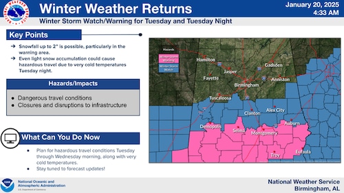
Here are the winter storm watches (in blue) and warnings (in pink) for central Alabama.NWS
- Winter storm warning from 6 a.m. Tuesday to 6 a.m. Wednesday for Marengo, Dallas, Lowndes, Montgomery, Macon, Bullock, Russell, Pike and Barbour counties.
The weather service in Birmingham said total snow accumulations up to 2 inches will be possible.
- Winter storm watch from Tuesday morning through late Tuesday night for Randolph, Sumter, Greene, Hale, Perry, Bibb, Chilton, Coosa, Tallapoosa, Chambers, Autauga, Elmore and Lee counties.
The weather service said total snow accumulations of 1 inch will be possible.